Putting GeoCenter on the Map
The GeoCenter team is all over the map…literally. The recent completion of a series of regional geographic analyses for USAID West Africa is due, in large part, to FCG’s Patrick G. A driving force, he put forth an incredible amount of energy and passion earlier this spring into providing extensive mapping and analysis services with health experts.
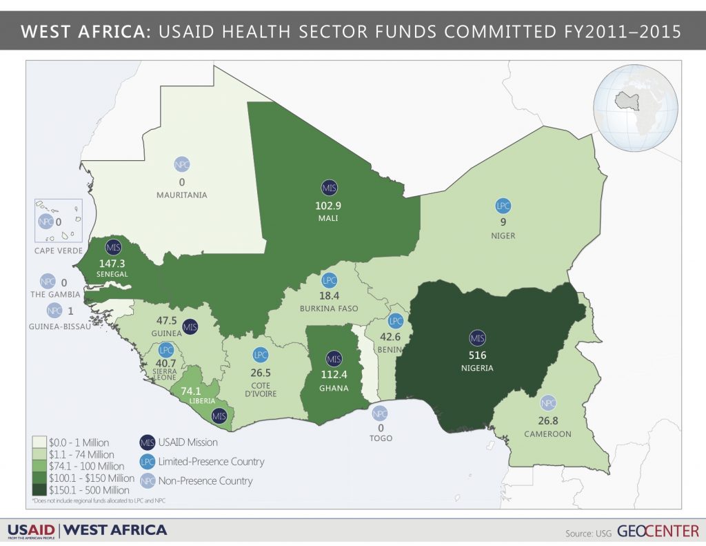
Twenty-one countries comprise West Africa, a diverse region that faces significant development challenges. In response, USAID/West Africa works with regional partners to increase the utilization of quality health services, among addressing other development priorities. The results of the GeoCenter’s analytical support helped the West Africa Regional Health Office (RHO) identify seven priority countries that have the greatest need for USAID/West Africa’s health resources for family planning, health systems strengthening, and key populations. The countries include: Benin, Burkina Faso, Cameroon, Cote d’lvoire, Mauritania, Niger, and Togo.
![Headshots-11[2]](https://freedomconsultinggroup.com/wp-content/uploads/2016/07/Headshots-112-300x200.jpg)
“The analysis I conducted was for the West Africa Regional Mission,” said Patrick. “They focus on regional issues, whereas country-specific missions focus on just the needs of that country. I supported the health team to design a project that planned how they will allocate funding over the next five years. After a “project” is designed, more specific “activities” are designed to implement the project. Our goal is to be equally embedded in this next process so that our analytical support can further assist in making data-driven decisions at a more granular level and maximize the development impact of USAID’s resources.”
 After the analyses were completed, and the Mission’s senior leadership approved the project design report, the GeoCenter received great appreciation from the health office for the professionalism, exceptional quality of work, and customer service that Patrick and the entire GeoCenter team approached this opportunity with.
This is yet another great example of the GeoCenter’s efforts to apply geographic analysis to international development challenges and improve the lives of those in greatest need – We’re so proud to recognize our own in this significant accomplishment! To see the West Africa analysis work, check out the ArcGIS online gallery.